|
The
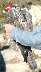
last month of January, the Equip de Biologia de la Conservació
- Àliga Perdiguera of the Universitat de Barcelona, placed
GPS-Satellite emitters to three adult males of Bonell'is eagle
of territories located in the region of Alt Penedès (province
of Barcelona). This system will allow to obtain several daily
locations of every animal with high accuracy. This
action is included within the project SITXELL that is carried
out from the Area of Natural Spaces of the Diputació de
Barcelona with the objective to obtain, to analyze and to
valorize data on the open spaces (urbanization not allowed) of
the province of Barcelona. In this sense, the presence and use
of the territory by the Bonelli's eagle is a variable that has
been considered opportune to integrate in this process of
valuation of the open spaces. For this reason, between years
2002 and 2005 the conventional radio tracking is being used to
get information about the use of the space and the selection of
habitat of 14 adults of Bonelli's eagle of 8 different
territories. When the data of the 3 units with GPS-Satellite
emitters are been obtained, there will already be information
about all the occupied territories of this species located
completely in the province of Barcelona. This information will
be very useful facing being able to preserve these nesting and
hunting areas of the Bonelli's eagle. |
|