|
The
use of GPS-Satellite in the study of hunting area and habitat selection
in the Bonelli's eagle
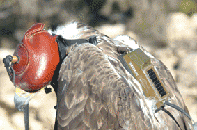
In this sense, the new technologies and the reduction of the weight and size of GPS emitters already allow their use in species like this. At the beginning of 2006, 3 territorial adult males of Bonelli's eagle in the province of Barcelona were individualized with emitters Microwave PTT-100 45 grams Argos/GPS (equipped with Ground Track), that were placed with teflon harnesses. Although it was hoped to receive 16 daily locations by individual, these emitters are only allowing to obtain, in a telematic way, an average of 2.7 daily UTM locations of each individual, mainly because of the loss of cover GPS and difficulties of solar load of the battery in the steep territories, but with an error of precision inferior to 15 metres, and in addition, also can indicate the altitude, the direction and the speed of the animal. The preliminary data collected during the first 6 months indicate that in a year sufficient information of the areas will be able to be obtained about the hunting areas, the centers of more activity and the use of the habitat. At the moment, the possible slants associated to the methodology are not known. In comparison with the conventional terrestrial radiotracking, the use of the GPS-Satellite emitters does not allow to obtain data about the behavior of the bird, of interest for the study of the ecology and conservation. Nevertheless, they save field effort, they elude the transcription of information to the programs of data processing, which avoids interpretation errors, and offers locations (although with much less daily frequency) of high accuracy, being a useful methodology in the management of threatened species and the territorial arrangement.
|