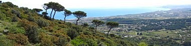
The habitats map of Litoral range
This mapping of CORINE Habitats and European Union Habitats of Interest (HCI), at 1:10,000 scale, includes all the
Park of Serralada Litoral and some nearby areas, located between Maresme and Vallès Oriental regions. The total mapped area is 7,366 hectares.
The mapping was done using the ortophotomaps (1:5,000 and 1:2,500) of the
Cartographic Institute of Catalonia (infrared and colour) and the fieldwork was conducted in Spring and Summer of
2012 and
2013, even though the territory included in the Serralada de Marina Park was mapped in
2010. The legend consists of CORINE units cited and explained in the
Catalan Habitats Manual. The cartographic information is structured in two layers, one of polygons and another of points. Each of which contains the information of the CORINE Habitats and the European Union Habitats of Interest (HCI). The minimum area for polygons has been set to 0,2 hectarees. Habitats which occupy less surface, are represented as points. Moreover, throughout the fieldwork we noted the location of those populations of alien species that we have considered most widespread and visible, which have been added to a points layer. In the whole area we mapped, we could create a total of 2,664 polygons and 611 points. In total, 114 habitats were detected; 15 of those are European Union Habitats of Interest (HCI), and 3 of those are priority. The alien species layer contains 64 taxa and 354 points. Furthermore, the fieldwork has enabled locate some new flora species in the Park of Serralada Litoral or nearby areas, or new populations of rare plants or plants not founded for a long time. The most important floristic citations can be founded in the attached report.
The
Natural Parks Network of the
Diputació de Barcelona has promoted and financed the habitats mapping of this natural area.
Author: Moisès Guardiola.
Implementation period: 2012 and 2013.
Delivery Date: 2013.
Download maps (ETRS89)
[
SHAPE]