HIREM
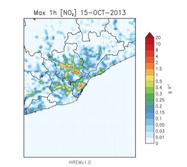
High Resolution Emission Model (HIREM) is an emission model developed by the MAiR group that includes emissions from natural sources (particles from oceans, dust or hydrocarbons emitted by vegetation) and emissions from anthropogenic sources (traffic, domestic and industry). As nesting is used for the domain coupling, the meteorological, emission and photochemical models must deal with grid variability and various domain ranges. Then, the HIREM methodology differs from one domain to another. For smaller domains as D3 and D4 HIREM model uses bottom&up methodology to calculate pollutant emissions which is based on working out each type of source in a particular way using local information. For bigger domains, D1 and D2 HIREM uses top&down methodology, which includes pollutant emissions from European annual, inventory EMEP/CORINAIR1. The basis of the disaggregation method is the soil uses CLC2006 (Corine Land Class 2006) with 250m resolution, coupled with different statistical functions, including socio-economical variables. This last methodology is used in nested air quality systems when there is no available information of emissions in specific areas. HIREM model is continuously updating and includes as primary pollutants nitrogen oxides (NOx), volatile organic compounds (COVS), carbon monoxide (CO), sulphur dioxide (SO2) and particles smaller than 10 µm and 2.5 µm (PM10 and PM2.5 respectively).

References and links
European Environmental Agency, 2013. Corine Land Cover Land Class Raster data 2006.http://www.eea.europa.eu/data-and-maps/data/corine-land-cover-2006-raster
European Environmental Agency, 2007. EMEP/CORINAIR Emission Inventory Guidebook. Technical Report No.16/2007.
http://reports.eea.europa.eu/EMEPCORINAIR5/en/page-002.html

