
|
Geografia d'Europa: textos de suport |
The Romans were the only people ever to control the entire length of the Danube from its source in the Black Forest to the point where it flows into the Black Sea. The river formed the northern border of their empire and was fortified to keep out the Germans, whom the Romans dismissedrather unfairly, perhapsas barbarians.
Both the Romans and the Germans worshipped the Danube as a god. The Romans regarded him as male and called him "Danuvius," from which we clearly derive the English name for the river. The Germans, however, regarded the river as a female and called her "Donau," preceding the word with the feminine article: "die Donau."
Nobody can be sure why the Germans decided that the Danube was female. Nor do we really know why the Rhine"der Rhein"is masculine. It has long been a matter of conjecture and much heated debate. Scholars have pointed out that the early Germans thoughtfully provided their rivers with spouses. It was only reasonable that "Father Rhine" should have as consort "Mother Danube." As late as the Romantic Period of the 19th century the Germans were still putting up statues that depicted the two as a fruitful couple.
But why did the Germans decide that it was the Rhine who should be a "he" and the Danube a "she"? Why not the other way around? One reason, involving a considerable measure of male chauvinism, has been much bandied about. If you are a member of the Fair Sex and feel that your indignation may be aroused, you should omit the following paragraph.
The reason is this: the Rhine has a strong, consistent flow throughout
the year, whereas the Danube has a changeable and unpredictable flow. Strength
and consistency were equated with the male, and the temperamental nature
of the Danube was considered characteristic of the female sex. It is as
simple as that! Ladies may wryly reflect on the fact that men's minds also
seem to have worked consistently over the ages.
The Danube has a length of 1,770 miles, or more than twice the Rhine's 820 miles. Generations of western European schoolchildren were taught that the Danube was Europe's longest river. But this is no longer so. When the Iron Curtain was recently pulled aside, everyone was happy to admit that Russia wasafter all the trials and tribulations of the Cold Warnevertheless part of a Europe that was now seen to stretch to the Urals. On the whole this was well and good, but one perhaps regrettable result of "moving the goalposts" is that the Danube has been unceremoniously demoted to Europe's second longest river after Russia's Volga. The Volga River, with a length of 2,293 miles, is some 520 miles longer than the Danube.
But there is always some consolation to be found: the Danube still has the greatest flow of any river rising in Germany. Its annual discharge is three times greater than that of the Rhine and comes respectably close to equaling that of the Volga, despite the latter's greater length.
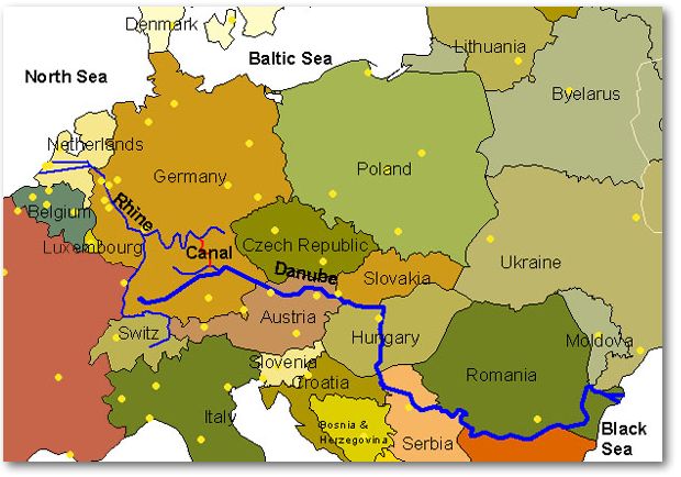
The Danube forms an international waterway 1,498 miles long from the Black Sea to the limit of navigation for barge traffic and cruise ships at Kelheim in southern Germany. It crosses or skirts some ten countries: Germany, Austria, Slovakia, Hungary, Croatia, Serbia, Bulgaria, Romania, Moldova, and the Ukraine.
One notes that the number of riparian states has increased from eight
to ten in recent years. Yugoslavia has collapsed into the separate states
of Croatia and Serbia, while the Soviet Union has been replaced by Moldova
and the Ukraine. In addition, with the recent division of Czechoslovakia
into the Czech and Slovak Republics, the Danube flows past another capital
city: Bratislava, the capital of the Slovak Republic. The river's three
other capital cities are of much longer standingVienna, Budapest, and
Belgrade, all of which were Roman garrisons.
The northern border of the Roman Empire ran along the line of the Danube-Main-Rhine Rivers. Unfortunately, the river system was not continuous and Roman ships sailing up the Danube could proceed only to a certain point, beyond which they could go no further. The cargoes then had to be laboriously unloaded and carried over a land-bridge until the headwaters of the Main were reached. At that point, the cargo could once again be loaded onto a ship that would carry it down the Main and on into the Rhine to reach Roman cities such as Mainz or Cologne.
Charlemagne dreamed of cutting a canal through this land-bridge and began work in 793. Unfortunately, the task was beyond the picks and shovels of his day and it had to be abandoned until a later ageuntil the 20th century, in fact. In 1921, the Germans, who envisaged a 106-mile-long canal linking the Danube with the Main and the Rhine, began Charlemagne's project once more.
The Main-Danube Canal, as it is called, had to cross the watershed of Europe by means of huge locks, some 100 feet deep. Construction was delayed by the Second World War, by spiraling costs, and by the bitter opposition of environmental parties who pointed out that the proposed route of the canal would take it through some of the most beautiful scenery in Europe. At one stage in the 1980s, opposition grew so strong that work on the canal was brought to a halt.
But at the end of the day, common sense prevailed. Everyone agreed that there was no point in having half a canal and that it should be finished. And finished it was, but under the strict supervision of the environmentalists who ensured that the final stretch of the canal was so integrated with nature that many people think they are sailing along a natural river until told otherwise!

The Main-Danube Canal was opened with great fanfare in September 1992. A brass band played Bavarian "oompah" music and priests presided over an interdenominational open-air church service. Fireboats trained their water cannon to form a symbolic curtain of water over the highest point of the watershed from which point water flowed both ways: eastward to the Danube and the Black Sea, and westward to the Rhine and the North Sea. Politicians who had fought for the completion of the canal delivered important speeches pregnant with the solemnity of the momentand objected to the presence of those who had sought to hinder completion of the project!
Since the opening of the Main-Danube Canal in 1992, the Danube now forms part of the transcontinental Rhine-Main-Danube Waterway that allows vessels to travel 2,200 miles from Rotterdam on the North Sea to the port of Sulina on the Black Sea.
Both the Rhine and the Danube are international waterways, which means
that they are open to the vessels of any nation. The Germans, however,
have shrewdly kept control of the Main-Danube Canal as a national waterway.
This, of course, is the central link without which the whole system is
worthless. Whether deliberately or not, the canal was built so that it
is too narrow for the wider vessels employed by former ideological and
economic foes from the old Soviet Bloc. Thus the wider Russian and Ukrainian
ships, for example, can proceed no farther than Kelheim, where the Main-Danube
Canal begins. The German river fleet has been spared competition by foreign
fleets that would have undercut them. Whether or not this was done on purpose
is still a matter of debate.
The Source and Course of the Danube
The traditional source of the Danube lies in a park at Donaueschingen, at a height of 2,230 feet on the slopes of the Black Forest. The river bubbled happily from a stone basin adorned with a buxom female to symbolize the fertile blessings of water. It was a most convenient source as it could easily be visited with the children on a family walk.
However, in 1955, a determined explorer managed to hack his way through dense undergrowth on the upper slopes of the Black Forest. At a most inconvenient height of 3,537 feet above sea level he discovered the true source of the Danube in a region difficult of access. This streamthe "Breg"soon joins with the "Brigach" to form the Danube.
The beginnings of the Danube are unsure and uncertain, and Johann Strauss has captured this in the muted opening bars of the waltz he wrote in honour of the river. The Danube is constantly disappearing down cracks into the limestone and reappearing somewhere else. The traditional source in the park is just one of many such springs.
In fact, when scientists attempted to map the unseen network of underground drainage by colouring the water with dye, they discovered that some of the Danube water actually ends up in the Rhine after flowing through ten miles of unexplored caves.
The Danube meanders across Bavaria and breaks through a limestone gorge at Kelheim, where it is joined by the Main-Danube canal. Below Kelheim, the Danube is navigable for larger river traffic, including cruise vessels.
At Passau, the Danube is joined by the Inn River that rises in the Swiss Alps and drains much of Austria. As the Inn is wider than the Danube and carries more water, the Swiss and Austrians have long argued that the entire river should be named the "Inn" and not the Danube.
From Passau, the Danube enters Austria and begins its most beautiful stretch as it flows through the steep, wooded foothills of the Alps. The Wachau Valley is the Danube's answer to the Rhine Gorge. The craggy heights are studded with ruined castles (including that of Richard the Lion-Heart at Durnstein) and the steep slopes are clothed with Austria's finest vineyards.
At Vienna, where the river is already 900 feet across, the Danube enters a huge basin of flatland some 300 miles across that stretches past Budapest and onwards to the east of Belgrade. Here the vast grasslands of Hungary became the "granary" of the Austrian Empire.
The Danube flows unhurriedly through the flat expanse except in two places. The first is the "Hungarian Gates," where the Danube cuts through the low mountains of the Western Carpathians just before reaching Bratislava. The Hungarian Gates markedas the name suggeststhe entrance to Hungary, and the traveler will see the remains of the Roman and medieval forts that guarded this strategic passage.
After Bratislavaitself strategically situated on the heights of the Hungarian Gatesthe Danube continues to flow through the vast, flat plain until suddenly it once again runs up against a fold of the Western Carpathian Mountains and cuts through them in a spectacular gorge. Until now, the Danube has been flowing to the east, but here its course changes dramatically to the south. The change is so abrupt that the region is named the "Danube Knee" for the very simple reason that the course of the river resembles a giant knee.
To the east of the Serbian capital, Belgrade, the Danube breaks through the Southern Carpathian Mountains in a dramatic series of gorges some 90 miles long. This stretch of the river is generally (although incorrectly) referred to in the plural as the "Iron Gates" after the "Iron Gate"the name given to the lowest gorge. Some two miles long, the Iron Gate proper is the deepest gorge in Europe. It is marked by "Trajan's Tablet," an inscription cut into the living rock to commemorate the Roman road built by Trajan in the 1st century AD. Trajan's road secured Roman rule over the fertile province of Dacia, today's Romania. For 90 miles, the mountains encroach on the Danube, sometimes hemming the river in to a width of less than 500 feet. Sheer cliffs rising 800 feet and more overlook the Danube in places. This was the most dangerous section of the Danube, where the river surged with enormous force.
Vicious rapids and fearful whirlpools were the dread of sailors until the completion of a huge dam in 1972 "drowned" the rapids under many feet of water and turned the turbulent river into a peaceful reservoir.
Once clear of the Iron Gate, the Danube enters another huge area of lowland known as the Danubian Plain, enclosed by the Carpathians to the north and the Balkan Mountains to the south. Here the river flows lazily over its flat floodplain, through marshes and swamps towards its delta on the distant Black Sea.
On reaching its delta, the Danube divides into three main channels that
flow through a wilderness of reed-filled marshes and sandy islands. When
the Danube floods, it reaches a width of 12 miles. The delta continues
to grow into the Black Sea at the rate of 80 to 100 feet a year. So much
silt is deposited that navigation is only possible by continuous dredging
of the Sulina Channel, which has been straightened and deepened to a depth
of 23 feet.
Some 70 species of fish are to be found in the Danube andas steps are taken to reduce the pollution of the rivercrabs and molluscs are beginning to reappear.
The sturgeon is the largest fish, attaining 20 feet in length. But it is confined to the delta where it comes to spawn, and it is here that it is fished for its caviar. The largest fish to be found along the entire length of the Danube is the catfish, which can measure 12 feet and weigh 600 pounds. The catfish has a voracious appetite and swallows whole ducks and geese. One is even known to have gobbled up a poodle.
Everywhere there are the fisherman's favourites: tench, barbel, bream, and roach, plus the large predatory carp and pike. As the water quality improves, these fish are now once again considered safe to eat, although not everyone would agree. You will see solitary fisherman along the banks. And here and there you will see fishing nets suspended on a pole above the surface of the water. The fisherman lowers them into the river, waits a while for unsuspecting fish to come along, and then quickly raises the nets with his catch.
The Danube rises in a zone of temperate climate while its delta enjoys a climate thatin the summer monthsapproaches the subtropical. Due to the wide range of climate and habitat ranging from forest through grassland to vast marshes, most species of European birds are to be found. The delta is a huge breedingand feedingground for migratory ducks, geese, and swans, but also for birds usually associated with Africa such as pelicans, ibis, flamingos, cranes, and cormorants.
In Germany and Austria, herons and the occasional stork make their nests
in treetops which then die off as they are coated with white, acidic droppings.
Kingfishers are in abundance everywhere, although difficult to spot. Easier
to see are the birds of prey such as hawks and the occasional eagle. Vultures
frequent the lower course of the Danube.
Because of its moving sand and gravel banks (before the Danube was dammed, it used to move 6.5 million tons of the stuff past Vienna each year), its floods and rapids, plus sudden and violent storms, the Danube was always a potentially dangerous river. Emperor Nero lost two ships laden with two million gold coins on a journey from Vienna to Budapest. Pirates once captured a Roman cargo of three million gold coins, only to sink themselves.
Nevertheless, before the arrival of good roads and the railway in the last century, rivers were the easiest way of getting through the dense forests of Europe. In an age before bridges, rivers also formed natural borders. The Romans used the line of the Rhine-Main-Danube as their northern border and built settlements that have grown into Regensburg, Passau, Bratislava, Vienna, and Budapest.
In the Middle Ages, the Danube was the most important trade route in
the world and cities on its banks grew rich. The huge baroque square of
Linz shows the wealth generated when the town was an important international
market, the meeting place of traders from Scandinavia and the Near East.
Great abbeys and monasteries such as Durnstein and Melk were built with
the profits largely earned by engaging in Danubian trade.
Before the arrival of steam-driven ships in the 1840s, man's relationship with the Danube (and all other rivers, for that matter) was an arduous one born of necessity.
Sailing downriver was no problem. The average speed of the unharnessed Danube varied from four to six miles an hour. A shipunder the pull of gravitywould travel slightly faster, thus giving it manoeuvrability. Vessels had a shallow draught, flat bottoms, and rounded "noses" so that they could more easily ride over shallows and sandbanks. If rapids were considered too dangerous, sailors simply avoided the risk by moving the cargo (and sometimes the vessel) around them by land.
It was sailing upriver that posed a problem. Ships could be powered by oars and by sails if the wind happened to be in the right quarter, which was not often the case as the prevailing west winds blew against ships attempting to sail in a westerly direction upriver.
Thus, from Roman times, the only reliable solution was to throw a rope
ashore and pull the vessel upriver with teams of men, horses, and oxen.
It was a laborious and costly exercise, which meant that only valuable
goods such as wines, spices, and salt could make the effort worthwhile.
As a result, vessels were built to sail downriver once and were then broken
up for timber in Vienna or Budapest. There was comparatively little upriver
traffic.
Steamships and the Harnessing of the Danube
Work to tame the Danube and turn it into a more reliable waterway began, more or less, shortly after the 1800s, and it accelerated with the arrival of the first steamships. A number of factors came together, and they can be summarised as follows:
Like the Main and the Rhine, the Danube wandered over its valley in many shallow arms choked by islands and sandbanks. Man forced the river to flow between stabilised banks and this increased the speed of the current with the result that it eroded away the bed of the river to form a deeper navigable channel.
The Danube was notorious for the way in which floods and low water could alternate without rhyme or reason at any time of the year. There was a 45-foot difference in the annual low- and high-water marks. At low water you could often ford the river on foot, while at high water the river became a treacherous enemy flowing as fast as ten miles an hour and more. The solution was to dam the river at intervals to turn the Danube into a series of reservoirs. These reservoirs are capable of absorbing floodwaters and rendering them harmless. Later, these same floodwaters help guarantee a sufficient depth of water for navigation through the rest of the year. The first dam was built at Passau in 1926 and since then a series of further dams has been constructed downriver. Below Vienna, the latest lock opened in the summer of 1998. More dams need to be built on the Upper Danube in Bavaria and also in Hungary before the river is entirely freed of the annual difficulty of low water in summer.
Practices which had hindered shipping for centuries were abolished. The robber barons, who spanned chains across the river and taxed or robbed passing merchant-shipping, had already been eliminated when the introduction of artillery allowed the destruction of their once-impregnable castles. But now it was the turn of others, as increasingly centralised governments awoke to the possibilities of river transportation in the new age of steamships. Abuses which had long hindered river trade were made illegal. The many toll stations were abolished, as was the "Stapelrecht," which gave certain towns the right to force passing merchants to offer their merchandise for sale. Mills that had blocked the arches under bridges or occupied the deepest part of the navigable channel (where the current was strongest to turn the wheels) were made illegal. Fishermen were forbidden to obstruct the river with their nets.
Improvements on the river opened it up for the first paddle-steamers. The earliest ones were not very powerful and had difficulty sailing upriver against the current. One answer was to do away with the paddles (which were forever being damaged by contact with the bed and banks of the river) and allow the ship to "drag" its way upriver on a chain. The principle of the "Chain-Ship" was introduced from France and was very successful at the time. Above all, it allowed the weak steam engines of the day to make slow but sure progress against even the strongest current. In a sense, the ship was always anchored to the chain.
It worked like this: a chain was laid along the bed of the river where the water was deepest. The ship took up the chain at the prow, passed it over a series of revolving drums (which "wound" the ship along the chain), and then dropped the chain back into the river over the stern. In time, chains were laid from Passau to Vienna.
Eventually, the Chain-Ship was overtaken by more powerful vessels, and ultimately by propeller-driven ships that had the advantage of greater maneouvrability as they were not tied to a chain.
Let us briefly trace the most important developments in Danube shipping this century:
For the early part of the century, and until shortly after the Second World War, the most common sight was to see a tug-ship (driven first by steam and later by diesel) pulling a convoy of barges that had no power of their own. This was unwieldy and difficult. In particular, if a convoy being towed downriver wished to dock, it had to first sail past the docking place and then turn before sailing back upriver. The barges (without any power of their own) could only be brought to a stop against the current.
A further disadvantage of the "convoy" system was that each barge needed a crew to steer, so it was expensive in manpower. Thus the convoys slowly disappeared and were replaced by self-propelled barges, each of which had its living quarters for the crew. Often it was a family affair: Father was the captain and Mother doubled as his first mate. The children were kept aboard until old enough to be sent to special schools. You will still see these barges with net curtains and flowers in the window, perhaps washing on the deck, a child's playpen. Nowadays there is invariably a television aerial plus a family car, which is off-loaded by a crane whenever needed.
These family barges once provided a "romantic" way of life. However, they are fast disappearing as they are replaced by the more efficient "push-tow" units which Europeans first noticed on American rivers in the 1950s. These powerful vessels are basically tugs that can "pull" as well as "push." They have no cargo space of their own, but pick up and deliver barges laden with freight. This means that the push-tow does not stand idly by during loading and unloading. It can arrive, pick up a couple of barges, and be on its way in no time at all. There are usually two crews so that the expensive push-tow can be used 24 hours a day. (Radar allows travel by night and in fog.) The traditional family barges with a one-family crew can not compete and are slowly being forced from the river. Time is money.
Traditionally, river freight consisted of bulky and weighty goods that did not need careful handling: coal and iron ore, cereals, animal feed, chemicals and fertilisers, fuel oil, and building materials. However, the introduction of container traffic now allows the transport of fragile and high-value manufactured productseverything from televisions and furniture to domestic and industrial appliances, one supposes. The profit margins are thus much higher. Some ships are even adapted to take hundreds of cars, looking much like a floating multi-storeyed car park. Transportation of cars by water results in much less damage than transport by rail or road.
The latest development is the so-called "Fluvio-Marine," a craft that
can sail on both the river and the open sea. You will recognise these vessels
because they ride much higher out of the water and have a freeboard high
enough to cope with sea waves. What is their advantage? They can sail directly
from the Mediterranean, through the Black Sea and up to Vienna, for example,
without the need any longer to transfer the cargo between "seagoing" and
"river-going" vessels. Time and money are saved.
You will be struck by the busy barge traffic on the Rhine and probably surprised by the lack of it on the Danube. In one hour, you are likely to count more vessels on the Rhine than you will see on the Danube in an entire week. Put another way: the amount of freight that the Rhine carries past the German-Dutch border exceeds 200 million tons a year. The amount carried by the Danube at the German-Austrian border is somewhere in the region of one million tons and is not much higher lower down the river.
The first reason for this lies in the differing characteristics of the Rhine and Danube:
The Rhine has a consistent flow throughout the year. A general absence of floods and periods of low water mean that ships can sail fully loaded between Rotterdam and Basel in Switzerland for up to 360 days a year.
Navigation on the Danube is still restricted by floods and periods of low water. The Danube is also subject to freezing in winter as it lies in the colder interior of the continent. A common feature is the "Buran" (Russian for "blizzard"), which can cause the temperature to drop from a relatively warm 50 degrees Fahrenheit to a literally freezing minus 40 degrees Fahrenheit within a few hours. The Danube freezes so quickly that ships must make for harbour or risk being caught and crushed in the ice. In a severe winter, ice can bring navigation to a stop for several weeks. To sum up, the Danube can only be reliably used by vessels with a full load on an average of 300 to 310 days a year, or about two months less than the Rhine.
The second reason you will discover by looking at a map of Europe: The Rhine connects the busy industrial economies of the richest countries on the continentSwitzerland, France, Germany, and the Netherlandsand is heavy with trade between these countries.
The Rhine flows directly into the North Sea and connects with the busiest trade route in the world: across the Atlantic to the United States.
By contrast, the Danube links the economically backward countries of Eastern Europe: Slovakia, Hungary, Croatia, Serbia, Bulgaria, Romania, Moldova, and the Ukraine. There is relatively little trade among these countries.
Again, in sharp contrast to the Rhine, the Danube has the misfortune
to flow away from major trade routes on the Atlantic. It empties instead
into the remote and almost landlocked waters of the Black Sea, which give
access to the former Soviet Union and the Middle East, scarcely the most
economically vibrant part of the world. To reach the Atlantic, ships face
a long voyage through the Mediterranean.
Historical reasons for the failure of the Danube to become a more active commercial waterway can be summarised as follows:
In 1453, Constantinople fell to the Ottoman Turks, who renamed the city Istanbul. The Turks waged a "jihad," or Holy War, to convert the lands of the Danube Basin to Islam. Their attempt to conquer the whole of Europe was thwarted when their army of 300,000 was beaten in battle at the gates of Vienna in 1683. Nevertheless, the Ottoman Turks occupied the lands of the Lower Danube Romania, Bulgaria, Yugoslavia, and parts of Hungaryfor up to five centuries. Budapest, as well as much of the rest of Hungary, was occupied for 160 years. The Turks were at first benevolent rulers, but their good intentions turned to bloody suppression in the face of constant rebellions. Subjugated and cut off from the West, these countries failed to develop and, when the Turks finally withdrew, they found themselves culturally and economically backward in comparison with the rest of Europe.
The confrontation between Islam and Christianity found expression in the form of two great empires: the Austrian (later Austro-Hungarian) Empire straddling the lands of the Upper Danube, and the Empire of the Ottoman Turks controlling the lands of the Lower Danube. These two powers were constantly at war and for 200 years the only traffic on the Danube was formed by their navies.
By the end of the 19th century, the Turks had been driven from the lower Danube by the Austrians penetrating down the Danube and by the Russians surging upriver from the Black Sea. The yoke of the Ottoman Turk was removed and for a while it looked as though the Danube would at long last take on its role as an international waterway. But this was not to be so.
The removal of the Turkish "buffer" brought the Austro-Hungarian Empire into direct conflict with the might of the Slavic peoples who held the Lower Danube. Austria wanted to expand down the Danube to the Black Sea, but came into conflict with the small, upstart nation of Serbia with its capital at Belgrade on the Danube. Tension between the Austrians and Serbs led to the assassination of the heir to the Austro-Hungarian throne in Sarajevo in 1914, and Austria took this as a pretext to launch an attack on Serbia. However, the Serbs were Slavs, and Russiatheir big Slavic brothercame to their aid. Germany had promised to help Austria should Russia intervene, and the First World War broke out.
The war was a disaster for the Austrians and swept away their empire. On the eve of World War I, Vienna had been the capital of a huge empire encompassing territories occupied by Hungarians, Italians, Czechs, and Poles, to name but a few. Some 50 million people speaking 17 official languages (including Yiddish) composed the Austro-Hungarian Empire. At the end of the war, Vienna (still with a population of about two million) found itself the oversized capital of an Austria that had been stripped of her empire and was now a rump state of only five million souls. This explains why Viennabuilt at the height of the empirealways strikes visitors as being too vast and grand for a small country that even today numbers just over eight million inhabitants.
The First World War was only the latest round in a centuries-old conflict as the Catholic Germanic peoples sought to expand down the Danube, only to be resisted by the Orthodox Slavic peoples who wanted to expand up the Danube. While the Germans and the Austrians held the Upper Danube, the Lower Danube was largely the preserve of Slavic peoples: Czechs, Slovaks, Yugoslavs, Bulgarians, and Russians.
The First World War was not the "war to end all wars" because the German-Slav conflict was renewed when Hitlerseeking "Lebensraum" or "Living Room" for the Germansgobbled up Czech territories on his doorstep. The world did nothing, thus emboldening Hitler to invade his other Slavic neighbours, the Poles. The Fuhrer had gone too far, and the Second World War was on. Needless to say, the Danube became part of the battleground.
When the war was overit had been agreed by Roosevelt, Churchill, and Stalin at YaltaEurope would be divided up between the victors. But on what criteria? Easy enough: Russia would take the Slavic EastCzechoslovakia, Yugoslavia, and Bulgaria, plus the non-Slavic Hungarians and Romanians who simply had the bad luck of finding themselves islands in a Slavic sea. The Americans and British would take the rest of Europe to the west.
Thus, in the words of Winston Churchill, an "Iron Curtain" descended over Europe, dividing her down the middle and crossing the Danube between Vienna and Bratislava. The Cold War was on.
Why, you might ask, was the Iron Curtain so important? To answer that, we have to go back to the time of the First World War when Russia realised she was still a feudal economy lagging centuries behind her industrialised enemy, Germany. Thus, in 1917, in an attempt to kick-start the Russian economy and catch up with the West, the Russians embarked on the most disastrous experiment in their long history: they adopted Communism.
All might have been well and good had the Russians been content to keep their communism to themselves, but this they refused to do as they were determined to export it to their neighbours. "Workers of the world, unite!" A worldwide revolution was their aim.
Thus, when the Iron Curtain descended over Europe, it divided two incompatible ideologies. The lands of the Upper DanubeGermany and Austriawere part of a free capitalist Western Europe that was at odds with the Communist Bloc holding the Lower Danube and Eastern Europe. Never in all its history had Europe been so completely and utterly divided against itself. The Communist Bloc sealed itself off hermetically from the West. Mutual suspicions led to fear and hostility. Both sides built up their armed forces and the ruinous arms race began.
The Soviet satellitesCzechoslovakia, Hungary, Yugoslavia, Bulgaria, and Romaniawere brutally exploited by their Soviet masters and their economies were ruined. In the end, they had very little to sell or trade abroad, but that scarcely mattered since they were effectively prevented from trading with the West. Instead, the Soviet Union exploited their economies, bleeding them dry. Man, the political animal, had once again contrived to deprive the Danube of her function as an artery of trade and communication.
The present conflict in Yugoslavia severed trade and communication along the Danube in the early 1990s and severely undermined the usefulness of the Rhine-Main-Danube Waterway that was opened with the completion of the Main-Danube Canal in 1992. It must be stressed again and againso that we learnthat the conflict in Yugoslavia is the direct result of the racial, religious, and political conflicts that have determined the history of the Danube lands (and of Europe) for a thousand years.
The great protagonists, or rather antagonists, have been the Germanic peoples of the West, the Slavic peoples of the East, and the Ottoman Turk who held the lower Danube for five centuries. These three groups have all struggled to expand their territories at the expense of the other and the strife has been further embittered by religious hatred: the Germanic peoples are Catholic, the Slavs are Orthodox, and the Turks are Moslem. Religious tolerance has been unknown. If necessary, some believe, a religious opponent can be converted at the point of the sword. Failing that, he could be driven from his lands and even exterminated. In the lands along the Danube, religion and military conquest have often made unlikely bedfellows!
Today's Yugoslavia is still playing out the struggle of three belligerent parties descended from the three great powers that once determined European history. First there are the Croats, whoalthough they are Slavslooked to the West, were converted to Catholicism, and became allied with Austria and Germany. In the Second World War, they fought on the side of the Nazis and practiced a policy amounting to genocide against their neightbours, the Serbs, arguably the most belligerent party in the present struggle. The Serbsa Slavic people and first cousins to the Croats with whom they speak the same languagelooked to the East, adopted Orthodoxy, and became part of the Russian sphere. They fought on the Russian side against their Croat cousins in the Second World War.
But both the Serbs and the Croats are united in their dislike of the third party, which has not been so much a belligerent party as a victim: their Moslem countrymen known as the Bosnian Moslems. The Moslems are a leftover from the hated Turkish occupation that for centuries had oppressed Croat and Serb alike.
Thus, when the strong hand of Tito was no longer there to keep order, old hatreds and rivalries exploded into civil war. Trouble first erupted when Croatia announced its intention of becoming independent of a Yugoslavia dominated by the Serbs. The Serbs were equally determined to prevent this and resorted to force of arms. In the end, the struggle was once again about land and power, as it had been for centuries. "Ethnic cleansing" became the order of the day as all sides struggled to expand their territory and cleanse it of their racial and religious opponents, often resorting to wholesale massacre.
A horrified world has followed this most barbarous of wars on its television
screens. If any good is to come out of the slaughter, this is it: old racial,
religious, and political hatredsif resurrectedwill destroy everyone.
There is an old Chinese proverb: "If you dig a grave for your enemy, dig
one for yourself at the same time!"
The Iron Curtain has been pulled aside and there is at last free communication among all lands along the Danube. Most of the impoverished economies of the former Soviet Bloc are making rapid strides and it is to be expected that in the future their growing economies will be in a position to seek trade with the industrialised countries of Western Europe via the Rhine-Main-Danube Waterway.
Optimists predict that all of Eastern Europeincluding Russia, with the vast and virtually untapped mineral wealth of Siberiawill eventually become part of the European Union. When this happens, the EUstretching from the Atlantic to the Urals and beyondwill become the world's single largest market. And the Danube, as part of the Rhine-Main-Danube Waterway, could become its main waterway. It will be interesting to follow developments during the coming years.
Unfortunately, for the reasons we have seen, there is as yet still little trade along the Danube. It will take time for the wounds of the past to heal and for new trading networks to develop. There were those who warned that the building of the Main-Danube Canal to connect the Rhine with the Danube would prove to be a costly white elephant. So far they are right. There is not enough trade to justify the canal. But that, too, can change more quickly than we might expect. Who, for example, would have believed that the Iron Curtain would disappear so quickly and completely?
In the meantime, we can be thankful that the Danube at long last flows through lands where people are finally learningand not before timeto get on with one another. The political tension has dissolved, and with it much of the time-consuming border control that used to accompany any cruise along the river. Cities that once decayed under Communism are being reborn.
As a result, a cruise along the Danube is now more attractive than ever
before. At least tourism is thriving and evermore luxurious river cruiserswhich
offer all the amenities of a floating hotelare being built to meet the
demand. Experienced travelers rank a Danube cruise as one of the greatest
travel experiencesespecially if they can link it with a cruise of the
Main and Rhinebecause of the sheer beauty and cultural riches that abound
along its banks. Remember that, since 1992, it has been possible to sail
nonstop across the face of Europe from the North Sea to the Black Sea along
the Rhine-Main-Danube Waterway.
Fuente:
Alumni Association & Alumni Holidays International, Inc.
University of Iowa
http://www.iowalum.com/voyagers/