 1962 www.bcn.cat/artpublic")
| |
| REPENSAR EL RÍO: USOS SOCIALES DEL RÍO BESÒS |
|
| RE-THINKING THE RIVER: SOCIAL USES FOR THE BESOS RIVER |
|
|
We
implemented this participatory worshop under request of the Sant Adri's
City Council, starting in 1997 and finishing just before the local
pollings 1999. OBJECTIVES We can isolate diverse implicit objectives in the formulation of this workshop. 1. - Objective participation. The
groups work process and organisation have as their first objective, to
empower the participation of the citizens regard to thinking, planning
and conforming public use proposals, to
approach, from a local and personal perspective, the possible developments and action plans on this territory of the city. 2. - Objective information. Through
the development of the workshop and given the characteristics of the
work that we will analyse later on, to seek a system of civic
information based on the representability of the
participants to set out and where possible to disseminate the information in their origin groups (Neighbourhood groups, cultural associations, etc) 3. - Objective education Through
the development of the activity, we seek to educate the participants in
technical subjects and to be capable of territorial and regional
analysis. Usually, this kind of training doesn't take place in the
participative processes since the mediation of the technicians prevents
the citizens to develop their discursive and project capabilities.
Participation in the workshop also proposes to be a way of learning how
to consider the real distance between the desire or the expectations
and the viability of the conclusions.
4. - Objective: extension to the community Because
of its diffusive characteristics, the process and the results of the
workshop enables, in a direct way, a good part of the population to «
participate» in the discussion and critique of the obtained results, at
the same time that the workshop becomes an open process, by being open
to new incorporations and to the opinions of the population as a whole.
The project methodology is sustained in five important elements: 1. - The conceptualisation or design of scenarios (scenario planning)
2. - Demarcation of the topic to develop 3. - The points in favour and against the topic to be developed. Hierarchization / territorialization of the possible needs 4. - The form of the proposals. Project Phase 5. - The communication of the proposal 5.1. - The exhibition.
5.2. - The explanation to the citizens 5.3. - The visibility. |
|||
|
|
|
|||
Structure of the CD-ROM Book We also introduce
the evaluation of the project by Barcelona Regional on the area of the
forum and the complementary media impact. As a complement, the CD ROM presents Sant Adrià's statistical data, the fundamental aspects of the project by Barcelona Regional , to allow the contrast between the civic proposal and the technical proposal and, finally, the citizen's guide published by Sant Adrià's City council. |
One year after we finished our project, the Municipality won a contracta in the framework of the EU URBAN II programme. The objective of Urban is to operate "on the economic and social regeneration of cities and neighbourhoods in crisis in order to promote sustainable urban development". Under request of the city council of Sant Adrià we signed and agreement to develope the project "Mapping La Mina". In parallel was created the Consortium of La Mina |
|||

|
| A visual analisys of the evolution of the territory |
|||
 |
|||
|
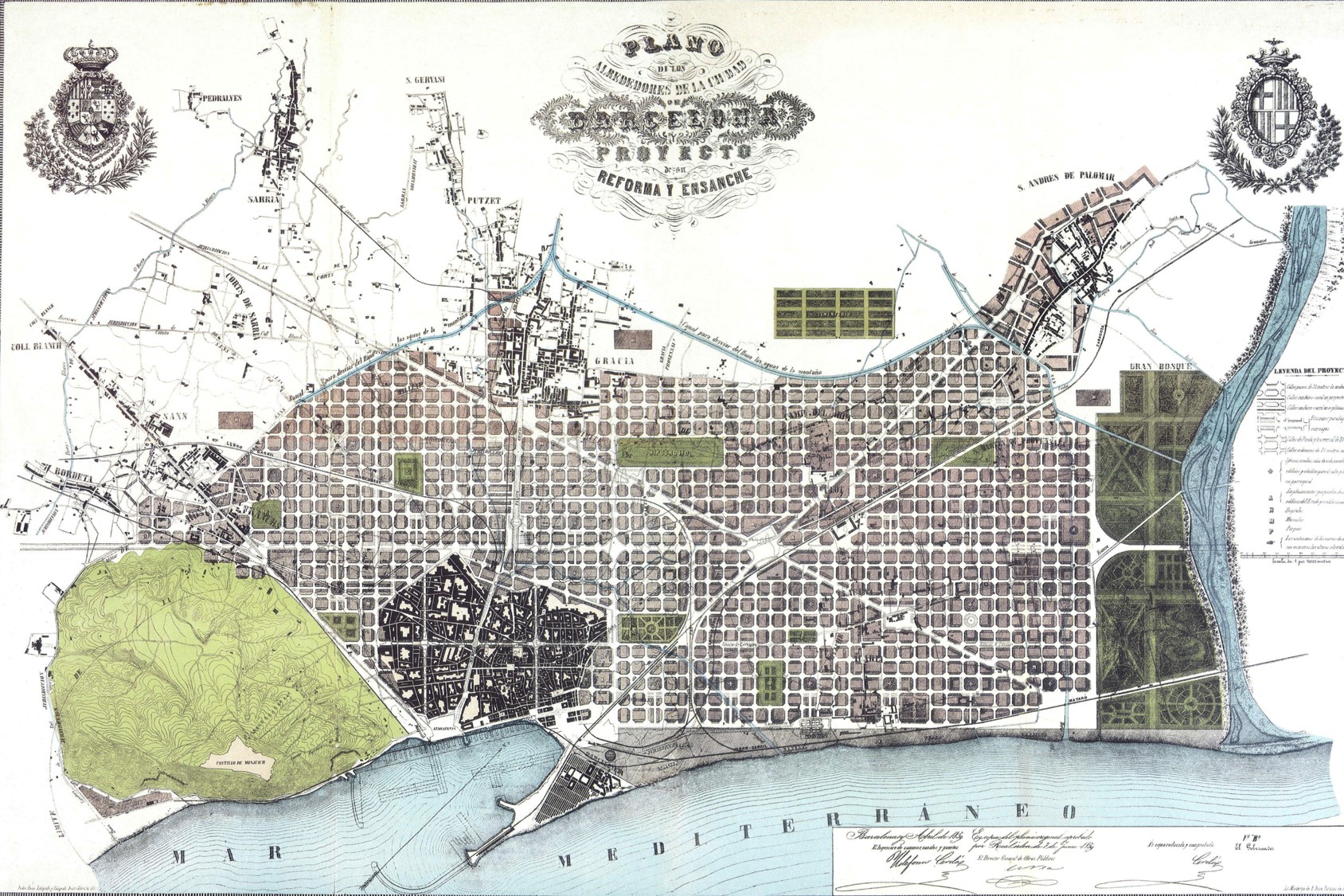
In 1854, Ildefons Cerdà developed the mapping plane of Barcelona plain that subsequently would provide the basis for Eixample projects. It can be appreciated that the Besòs is primarily an agricultural area
|
|||
 |
|||
|
1859. Reform and Expansion Plan for Barcelona by Ildefons Cerdà. In this project, the area is intended to Besos large urban park. Topic that will be repeated in subsequent projects
|
|||
 |
 |
 |
|
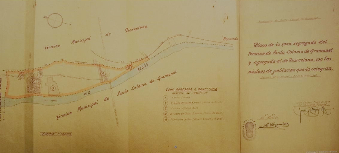
| 1897. Barcelona starts a plan for the annexation of the neighboring towns. However a border strip with river and close to Barcelona will be kept by the municipalities of Sant Adrià and Santa Coloma | 1899. The process of annexations, involves thinking a new expansion plan. Ricardo Alsina Amils will design a plan in which Besòs area combines the large park designed by Cerdà with new housing projects. | 1903-1905. Leon Jaussely, winner of the international competition known as "Linking Plan",keep the mentioned ideas. In the area presently occupied by neighborhoods of Bon Pastor andBaró de Viver, he plans a big railway sorting station |
|
 |
 |
||
| 1920. The general plan of the city, shows us how the one hand the Eixample is growing slowly, while Besòs area remains agricultural land. | 1932. The plan shows the growth of the Eixample. The Besòs remains agricultural | ||
 |
 |
 |
|
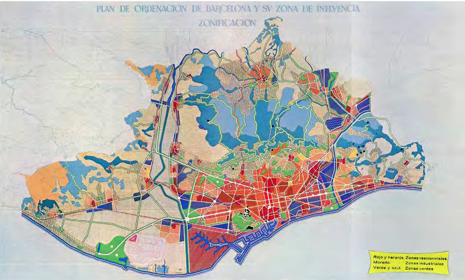
| 1944. The Official Gazette publishes the Order of annexation to Barcelona of the northern territories of the river. The southern region continues to depend on Sant Adria de Besos | 1945. Plan for the Eradication of shanties. The large growth of Barcelona after the civil war, led to the emergence of large areas of shanties. Alguna de ellas en la playa, próxima al río.Some of them on the beach, next to the river. | 1947. Preparatory studies of the Regional Plan. zoning criteria are introduced. Besòs area is classified as intensive residential zone and industrial area | |
 |
 |
 |
|
| 1953. Regional Plan with zoning. The Levant corresponding to Besòs area will be a priority in the development of city growth | 1950's. Proposal for implementation of large residential estates newly built | ||
 |
 |
 |
|
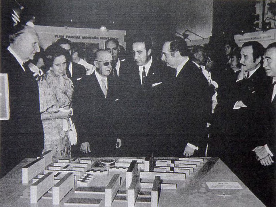
| 1959. Franco, with the mayor
of Barcelona, José Maria Porcioles, analyzing some of the proposals
ofresidential estates. Photomontage of residential estates of La Mina
and Southwest Besòs |
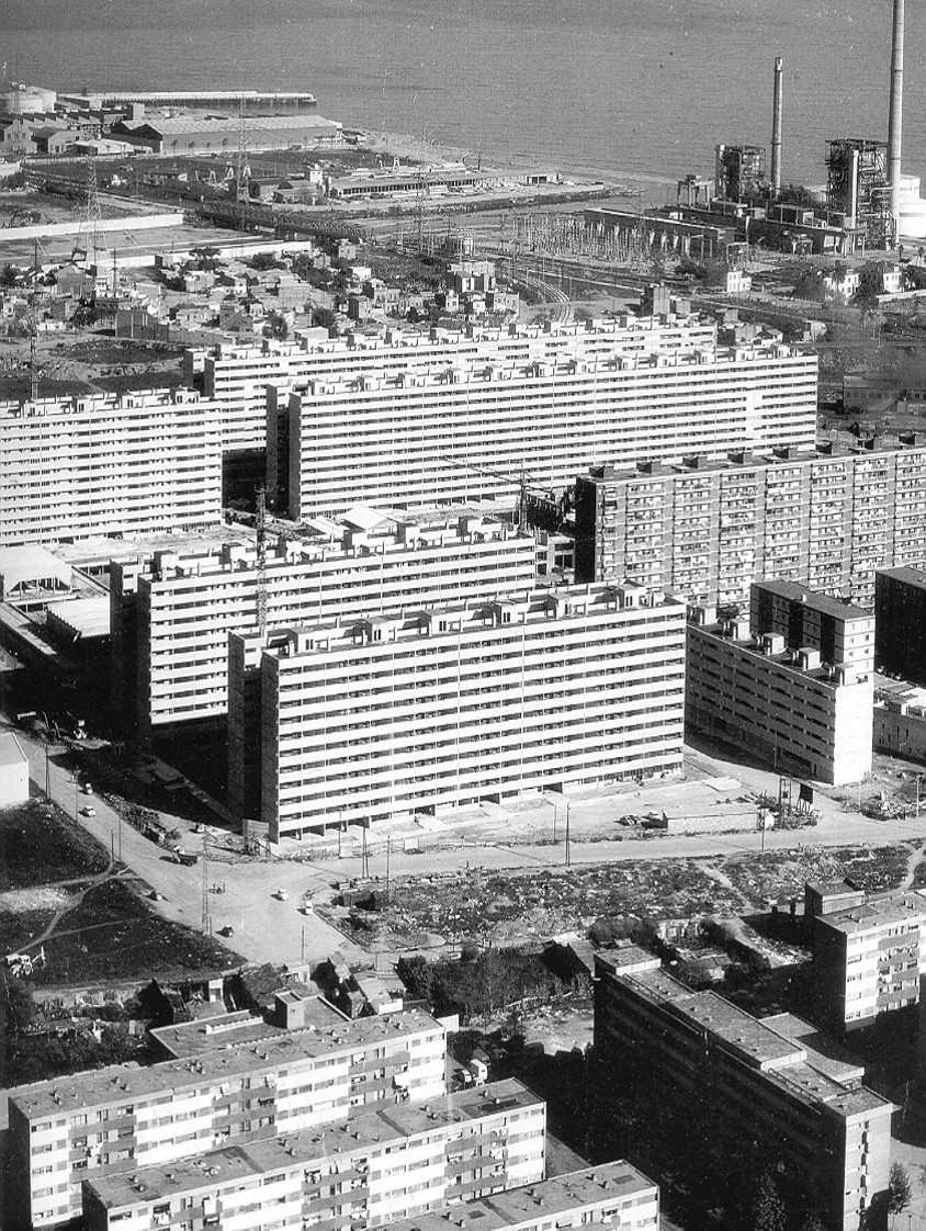
1960's. Aerial photo of the area where the housing estates of La Mina and southwest Besòs will be built. On the right the small neighborhood of La Catalana and the Besòs the river with no canalization seen. | ||
 |
 |
 |
|
| Distribution of housing estates built in Barcelona between 1926 and 1975 . | 1960's. Due to various reasons, in the 1960s, Barcelona began a process of deindustrialization. plans for the former industrial area of Poblenou (Plan de la Ribera) and connecting the city with the metropolitan territory arise. a new management of the city also arises from the idea of directional centers |
||
| PORCIOLES ( Mayor of Barcelona, 1957 -1973) DREAMS LA GRAN BARCELONA |
|||
| OLYMPIC GAMES (1968)… Moreover, the appreciation of the Tibidabo can provide an ideal place install for the Olympic Village to which you refer.
Question.- Represents the Villa Olimpica a help for the City to solve, after the Games, the housing problem?
Answer.- Fortunately, the housing problem in
Barcelona is in a process of immediate solution, but doubts fits that the
facilities built for the Games would serve to enable them cultural and
charitable powerful social facilities
|
 |
WORLD FAIR
The future
International Exhibition that the City want and crave, rightly evoked this
significant period of forty years between the first and second exhibition. The
four decades between ourselves and the exhibition of 1929, and forty years that
frequency sound in the ears of this generation more as an obligation to fulfill
and an appointment that summons us all. Each exhibition has its campus and its
urban purpose. In 1888 the Citadel; Montjuich in 1929. Another scenario before us: Tibidabo The new Universal exhibition will allow Barcelona to ratify her condition of living presence of Spain in the Mediterranean, motor cell of a new development plan for Catalonia and a decisive step for the urban transformation of Barcelona and its connection with major national and international guidelines .(1970) |
|
| |
Joan Brossa. Record d'un Mal Son [Memory of aNightmare] (1989). |
||
 |
 |
 |
|
| 1966. First the Master Plan of the Metropolitan Area of Barcelona and later the Metropolitan Plan 1976, reordered land use criteria. | 1970s. Aerial photo of the area. You can see the residential and industrial area of La Mina and the Besòs river now channeled after the great floods of 1966. | 1986. Coastal Plan of the Metropolitan Corporation of Barcelona. important instrument for remodeling the waterfront of Barcelona | |
 |
 |
 |
|
| 1993. L.Cantallops, M. Ribas and E. Roca. The Plan for
the right bank of the river Besos Sant Adrià. the idea of a marina
appears. On the right, render the waterfront of Barcelona including the
marina of Sant Adrià. |
1999. Plan to remodel the estuary of the river Besòs. | ||
 |
 |
 |
|
 |
This
plan raises overlooking the Forum of Cultures2004. It involves the
creation of a multipurposespace 14ha, construction of the marina of
SantAdrià, the creation of a coastal park and the riverBesòs
cnanalización for sports uses. Also it impliesthe formation of the
consortium Besos (Barcelona -Sant Adrià), as the land and projects management unit. At the foot, Daniel Torres image illustrating theproject by "Barcelona Regional" |
||
2000 |
As
well as the Consortium Besòs was in charge of the development of the
area of the Forum 2004, in the framework of the EU URBAN II programme
2000 -2008, was created another consortium, that of the La Mina
neighbourhood. The aims of the consortium funded by the EU Social Fund are: The overall purpose of the consortium, including in its statutes, is to direct, coordinate i run the implementation of the Plan of transformation of the Mina neighborhood. To fulfill the implementation of the Plan, the Consortium has the responsibility to carry out: - The implementation of actions in the educational, cultural, employability, social, housing, and safety prevention areas. - Coordination and collaboration for the correct application of, labor, cultural, educational, health, social housing and urban actions. - The actions aimed at economic development of the neighborhood in coordination with the City of Sant Adria de Besos. - The establishment of relations with other administrations, organizations and entities. - The actions of collaboration in the development of urban instruments adopted by the City Council of Sant Adrià. - Issuing reports regarding urban development works carried out in its territorial scope. - The provision of funding streams by persons or entities not consortium member. |
 |
|
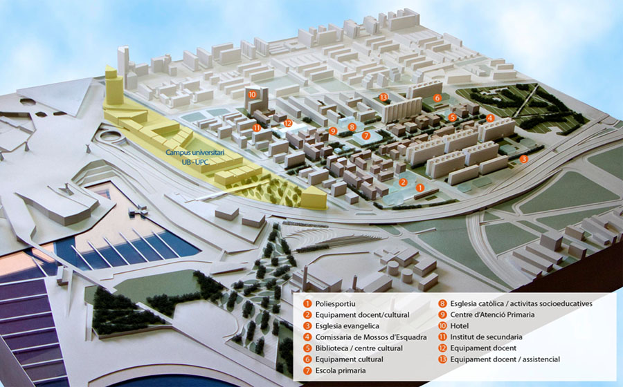
| As soon as in 2001 the architects Jornet-Llop-Pastor presented their
PERI (Special Plan of Reform) as a key element to help to the physical
and social transformation of the area. In the image the previous 1960`s plan |
|||

|

|
||
| 2001.
Jornet- Llop- Pastor plan. The Plan was awarded with the spanish
National Award for Urbanism (2006) and the European Award of Urbanism
(2010) |
|||
 |
|||
 |
|||
 |
 |
 |
|
 |
|||
| General
View of La Mina. In the centre the Rambla. The surface public art
project was developed by our Research Centre usin colored asphalt
(2006-2008) Download project |
|||
| Images of the Past |
|||
 |
 |
 |
|
 |
 |
||
 |
 |
 |
|

|

|

|
|
| PB98-1251 PB95-089 |