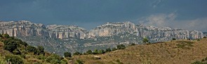
The habitats map of the Montsant range
The
Natural Park of la Serra del Montsant is entirely in the Priorat region. The habitat mapping began in 2009 and, once completed, it includes just over 13,100 hectarees of the municipalities of Cabacés, Cornudella de Montsant, la Bisbal de Falset, la Figuera, la Morera de Montsant, la Vilella Alta, la Vilella Baixa, Margalef, Poboleda, Torroja del Priorat and Ulldemolins. Thus, the total area mapped overcome in more of 4,000 hectarees the surface of the Natural Park.
The mapping was done using the ortophotomaps (1:5,000 and 1:2,500) of the
Cartographic Institute of Catalonia (infrared and colour) and the fieldwork was conducted in Spring and Summer of
2009,
2010,
2011 and
2012. The legend consists of CORINE units cited and explained in the
Catalan Habitats Manual. The cartographic information is structured in two layers, one of polygons and another of points. Each of which contains the information of the CORINE habitats and the European Union Habitats of Interest (HCI). The minimum area has been set to 0,2 ha for polygons. Habitats which occupy less surface, are represented as points.
Author: Moisès Guardiola.
Implementation period: 2009 to 2012.
Delivery Date: 2012.
Download maps (ETRS89)
[
SHAPE]