Analogue Modelling Laboratory
Analogue modeling is a well established technique whose purpose is to reproduce the geological processes that influence the generation and evolution of the geological bodies in nature. This is done by using analogue materials with scalable properties that allow to emulate the behavior of their natural equivalents (rocks). Analogue models are, hence, scaled reproductions of the geological bodies in terms of material properties, spatial and temporal distributions. If scaled properly, the evolution of the modeled bodies is comparable to the evolution of their equivalents in nature.
The most common analogue materials are dry quartz sand of different grain sizes, clay-cake, glass microspheres and silicone polymers, used depending on the experimental setup and the geological body to be modeled. In order to reproduce at small scale the brittle and ductile properties of natural materials, the properties of the analogue materials must be temporarily invariant and known during all the experiment.
To reproduce at laboratory scale the brittle and ductile behavior of rocks, the mechanical properties of analogue materials should be constant and well known during the experiment. The timescale of natural geological systems (thousands to millions of years) is also scaled to model the duration of geological processes. When it comes to dimensions, thickness, material properties and timing, the scale ratio between laboratory and nature is within the range of 1:100.000 to 1:10.000.000.
One of the main research lines of the Research Institute and GGAC group is the 3-D reconstruction and modeling of geological bodies. To complement the group’s expertise and strengthen the modeling resources, the Geomodels and GGAC’s analogue modeling lab was founded in 2009, thanks to the scientific infrastructure (UNBA08-4E-006) co-funded by the European Regional Development Fund of the “Ministerio de Ciencia e Innovación” of the Spanish government.
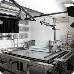
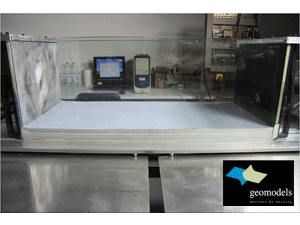
The experimental (analogue) modeling lab of tectonics and structural geology of the University of Barcelona (SIMGEO) consists of a modular modeling table designed to emulate a wide variety of tectonic settings: extension, compression, strike-slip, basement faulting, tectonic inversion, double-wedges, salt tectonics, gravitational glidding, etc… A total of six engines run by a digital controller allow uni, bi or triaxial tests transmitting the deformation to the mechanical arms. The number and configuration of the engines allow modeling any strain field. The rate and orientation of movement are monitored continuously by a computer allowing it to be varied during the experiment. The modeling table also allows to carry out models at different scales, from basin to crustal scale.
Digital time-lapsed photographs of the upper surface of the model are taken and controlled by a computer as the deformation progresses, allowing having a good control of the experiment evolution. These photographs are complemented by a high-resolution white light scan (SIDIO Pro from Nub3D) which captures the topography of the model during the experiment run, recording changes in topography at millimeter scale. The point cloud delivered by the laser scan is treated with CAD applications and other softwares (Polyworks) for later use in 3-D reconstructions. Finally the model is cut in homogeneous and equidistant sections. General and detailed photographs are taken for each section. These pictures are then transferred and referenced into a 3D framework according to a Cartesian coordinates system. Thanks to a 3-D structural modeling software (Gocad from Paradigm) it is possible to digitize the different structural and stratigraphic elements by keeping their coordinates and position within the model framework. Following the digitization of these elements is possible to carry out a 3D reconstruction of the original analogue model after the deformation (see Vidal et al., 2008 for detailed information).
Many of the boundary conditions in nature are not observed, and can only be inferred from numerical and/or analogue models. In the Geomodels Research Institute and GGAC we use both techniques to build three-dimensional geological models with more efficiency and accuracy, based on observations and interpretations from field and geophysical data.